|
|
|
|
|
|
|
|
|
|
|
|
 |
|
 |
|
|
Yap State, FSM - March 1999
|
|
|
|
|
 |
|
|
|
|
|
|
|
The Work Continues
|
|
|
|
|
|
|
March 4, 1999
It looks like we are in for some more rain today. Yesterday I thought we would escape it, but unfortunately we did not --- we got caught in the field. And just as the guys thought we would pack it in, I said we stay and finish our mapping --- so they got experience mapping in the rain.
March 6, 1999
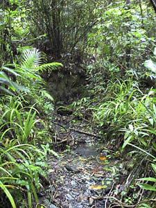 The tributary stream that we follow to reach the upper portion of our site: at the end of the drainage you see a wall of soil; at that point you turn right (north) and climb the small waterfall. The tributary stream that we follow to reach the upper portion of our site: at the end of the drainage you see a wall of soil; at that point you turn right (north) and climb the small waterfall.
As we were walking into the site today, I noticed this was the first time I have seen water flowing the length of the small tributary we have to ascend to get to the upper reaches of the site, where we have begun our mapping efforts. Normally there is no water, at least along the length of it, but there has been an inordinate amount of rain in the past couple of days, so the stream is flowing. Even the pools that were once dry are filled. There is one part of the stream that we have to climb --- the whole stream bed is rock, shist in fact (I think it also served as the source of much of the building stone we see on the site) --- and it is very slippery when it is dry, but with water running over it making a small waterfall, it was really slippery.
Still, even with the water, we made it up to the top of the site, and continued with the work we started last week --- mapping these architectural complexes that are returning to the jungle almost faster than we can cut it. The complexes consist of at least one six-sided stone house foundation, a sitting platform that is supposed to have backrests (according to tradition) --- though, alas, the complexes we are working on are so disturbed with vegetation growth, erosion, farming during Japanese times, and just general neglect after abandonment, it is nearly impossible to identify the features --- taro patches, and a series of terraces going downslope with stone retaining walls. There is a lot of pavement throughout a single complex. The terraces that are held up by retaining walls seem to be all paved, as well as the sitting platforms and house foundations, even drainages. The water control systems throughout this village are incredible --- there are a system of drains, usually paved, adjoining housing complexes to divert water and run-off away from the houses. Even slopes where there are no house foundations have a complex of paved drainages. Totally amazing to me. This is truly a sophisticated solution to living with the rains and run-off and protecting the effort put into constructing houses, terraced areas, paved areas.
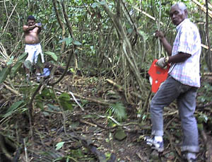
Mapping -- Mario, left, and Andrew, right
Mario has a real talent for drawing maps. His maps are beautiful, and he continues to experiment with the presentation of each map he draws.
As I said, we are dealing with architectural complexes that are gradually returning to the jungle. The remnants we are dealing with are bits and pieces of stone walls and alignments visible through the brush and sediments accumulating on the ground surface. From our brush-cutting efforts, basically our reconnaissance to see what was here in the site followed by our machete work, I have come to hate bamboo. There are too many places where bamboo has simply taken over. It tears apart foundations quicker than anything else; it generates its own ground cover, with old bamboo becoming the bed for the new growth, so gradually a clump of bamboo becomes a mound. And on top of a house foundation, it not only becomes a mound on a mound, but it expands and grows outward as well, disturbing, distorting and destroying the original alignments. Bamboo is nice as furniture and as shades, but not growing in your site.
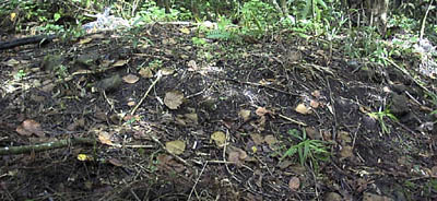
Our first architectural complex for mapping is Daf 1 (daf is the local term for the six-sided house platform), and there is only a single retaining wall visible within the foundation.

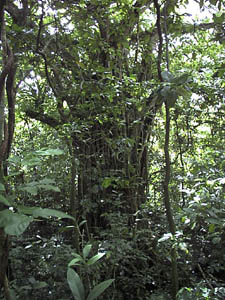
The huge banyan tree growing in the middle of a taro patch on-site: as I have mentioned before, Andrew says that banyan trees house spirits, and this tree in particular is visible from vistas outside the drainage (it is near the ridgetop). He said that at night, when he was growing up in this area, there would be a fire burning at the base of the tree. As this was abandoned land, it was always assumed the spirits of ancestors were coming to life and using the place.
We have not yet actually identified everything within the site, but I can say that the site spans a stream drainage, and is cut into two parts by this stream. Our efforts have been concentrated in the western part. Originally I had planned on us clearing the entire site before mapping it; but the amount of work that went into just clearing on the western slopes was so enormous that I decided we had best start mapping this side. It is a good thing too. Vegetation grows very fast here, but that was only part of the reason. We were getting to the point of information overload --- having to remember every alignment we cleared, every feature was becoming almost too much. And to think I was expecting to be able to cover about two or three of these sites during my stay here.
This is one of 34 sites listed in the oral histories as the first settled sites in the history of Yap. Like the others it is in an inland location, in the jungle just below the ridgetop savanna. Our project, this being the first stage, is to locate these 34 sites, map them, and then, at some point, begin more intensive archaeology within them --- that includes sampling with the intention of recovering datable materials with integrity that have survived the centuries of occupation. Dinay in particular plays an important role, in that it is supposed to be the place where fire and pottery were introduced to the people of Yap.
The site is upstream from the coast. You simply follow the stream out to an inlet along the coast. Not really very far, perhaps a kilometer or so. The site is perhaps about 2 km from Colonia, so scale here is another matter --- it is relatively close, so close in fact that there are days we have to take a taxi to the site! It costs us a dollar; for comparison, to drive anywhere in Colonia in a taxi costs 50 cents. There is a stone path that follows the main stream through the site; it follows this stream at least as far as the reservoir (to the south) that now blocks the course of the stream. It is a question whether this path continued all the way to the inlet at the mouth of the stream. The path also continues to follow the stream inland (to the north), but I stopped following it when it became a Japanese road. Where the inland route of this path went is also a mystery at the moment.
Along this main stone path following the stream course, there is an entrance to the village area at both ends (the total length of this segment of path is less than half a kilometer). These entrances are characterized by broad resting or sitting platforms, where travelers could take their repose before continuing into the village. Traditionally, there should also be uprights at the village entrance, but we did not find these. Maybe they were there once, but they are gone now. The path itself is highly eroded (at least that segment through the village); in fact, when we were clearing it, our only clues as to its presence were short segments of retaining wall visible along the sides of the path. It is a raised structure, with retaining walls on both sides.
The length of the site,and this is just an estimate, is less than a half-kilometer in any direction. Perhaps about 0.3 km along its longest axis, and 0.2 to 0.25 along its shorter axis. We have located about 20 house platforms/platform complexes overall. Of these, we have cleared about 15 complexes --- these being on the western portion of the site. On the uncleared, eastern portion, we have identified about five so far --- this from just passing through on our way to the western part of the site. But the eastern side of the site presents more difficulties because it is currently farmed. It is greatly disturbed, beginning with the Japanese-period farming and continuing up to today. Will we find additional house platforms on the eastern side when we start a more aggressive and intensive search? That question remains to be answered.
March 9, 1999
We managed to get our complex sketched --- that is important because our mapping efforts proceed based on that sketch. It helps us recognize what has and has not been mapped. This complex, for example, contains two house foundations in addition to nearly twenty other features which include terraces, platforms, and other rock alignments that seem to serve as steps, boundaries of paved areas and so on. It doesn't exactly help that the flatter areas have been disrupted by the Japanese era farming. That has done more to churn up pavements and dismantle features than anything else. I find that we will often start following an alignement out, then suddenly realize that it is a gardening bed that has used scavanged stones from nearby platforms. It is also frustrating. Just when you think you may have a terrace with only a few stones left in the retaining wall, you start seeing the outline of the gardening bed because it is very much unlike a traditional feature. Of course, you don't know that when you first catch the alignment; you are simply obliged to follow the thing out to the point where you can judge with reasaonble certainty that what you are seeing is or is not a traditional feature, and if it isn't, then you must at least ask yourself what you are seeing.
March 10, 1999
It is very hot and humid today. It has already rained pretty hard, this morning. It has been threatening rain most of the day. And of course humidity is way up, like the sky will explode in rain at any moment.
My discussions with the Chairman of the Finance Committee in the Legislature went well. All we (the two Johns and me) really did was to introduce several items that need to be addressed really soon by the legislature --- money for operation of the office for one. Most of the operational funds come out of the NPS grant. But when the Compact comes to an end, that funding may not be available --- or if it is, it will only be continued for a certain period of time. The office will essentially cease to exist unless the State of Yap steps in with an annual allotment of funds to run and staff the office. We had a very good reception for this. It is recognized that the office is essential, for development as well as economics. And the overall amount needed to run it is not that much. The Chair said they spend more than that on unnecessary things, so the amount requested is reasonable.
We talked about other matters too, each of which really hinged on the amendment of the historic preservation act, the researchers permit act, and the enabling act (where the office is placed within the government structure --- whether it is considered part of the Governor's office or placed under another government department). In terms of the latter, the Chair suggested it would make sense for the office to merge with Archives ---well, it should, especially if we get a Society of Historians created here; then all the information they record will have a home that makes sense --- the archives.
Next: Dinay: The project takes shape
|
|
|
|
