|
|
|
|
|
|
|
|
|
|
 |
|
 |
|
|
 |
|
|
|
|
|
Excavation and Mapping |
|
|
|
|
Kosrae State, FSM - July 1999
July 7, 1999
 I awoke this morning to see a couple of kids poling downshore in their canoe; then back again with a cargo of bananas. I awoke this morning to see a couple of kids poling downshore in their canoe; then back again with a cargo of bananas.
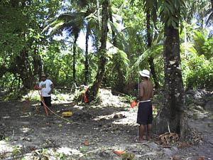
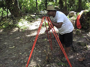
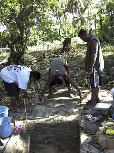
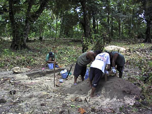
Our site work began in earnest today. I think the crew was glad to get away from brush clearing. They split into two groups: one to map with me, the other to excavate with Stan.
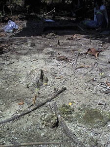
Our mapping began in the general area of Nena's initial datum point, but as I could not find this exact point yesterday, I set up the instrument at another location and simply tied into three of his existing mapping points. Our map is to include each of the locations Stan and I identified over several days last week, as well as the breadfruit trees (I want to know if there really is a pattern to their distribution, or if it is all in my imagination), midden deposits, artifacts, stratigraphic trenches, and a stone-by-stone point map of those areas identified as possible foundations. (If we can get them drawn out in a measured map, it will be much easier to either identify them as part of a foundation, as part of the wall debris, or as an isolated element that came to its resting position in some random fashion.)
Mapping begins at Walung
Alik at work
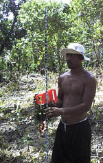 Alik was on instrument, while Burdy and Lyndon took charge of the rod and tape. Burdy and Lyn soon found that they had various decisions of their own to make, like where the next mapping point would be. I would provide them with direction, telling them I wanted this, this and this mapped; they then took over from there and began asking questions such as, should this be included or this? Alik was on instrument, while Burdy and Lyndon took charge of the rod and tape. Burdy and Lyn soon found that they had various decisions of their own to make, like where the next mapping point would be. I would provide them with direction, telling them I wanted this, this and this mapped; they then took over from there and began asking questions such as, should this be included or this?
These guys are good.
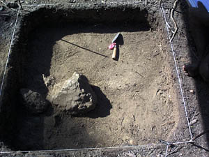
Meanwhile, Stan and his crew set up an excavation unit in the midst of some of the heavier midden deposits. The crew selected the exact location of the unit. I asked that in the screening they collect everything but the sand. And they did. The midden is loaded with fire-cracked rock, shell, fish bone, bird bone, and other bones that are likely fish (though they remain to be identified). By the end of the day they were able to reach the stable beach sand layer, about 75 cm below the ground surface. The profiles of this first unit show some really heavy crab damage (visible particularly in the east face) toward the base of the midden. Tomorrow they will continue the excavation and expand the unit toward the north, away (hopefully) from some of the heavier crab damage visible in the unit.
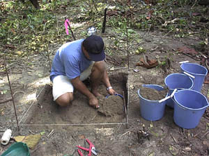
Walung, Unit 1
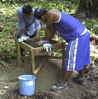
Walung screening
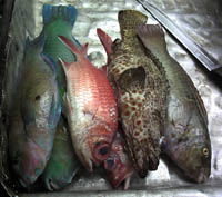
After work we had a treat: pandanus fruit. You don't eat the whole corn (or whatever the individual part of the fruit is called), but you chew on the pulp and suck out the juice. It almost tastes like a young corn-on-the-cob, when you pull it off the plant just before it is fully ripe. Elio caught a lot of fish today in his nets, so we had fresh fish for dinner.
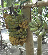
Walung bananas |
Pandanas |
July 8, 1999
Another half-day, as we are at the end of our working week. We expect Moses to pick us up around lunch time; high tide is supposed to be about 11, but I don't know if Stan made arrangements for our pick-up at that time. If not, we simply walk out to the boat.
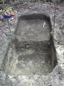
Mapping and excavations continued at the site. Stan and his crew opened a second unit, extending off the north face of Unit 1. By the second level, they had hit a hearth. It is just visible as a distinctly darker patch of soil, and it is loaded with charcoal, fire-cracked rock, larger pieces of shell, and more concentrated shell fragments. Their excavations stopped there for the day. We will pick it up again on Monday.
Laying out Unit 2
Units 1 and 2
In our mapping, we noted that the compound wall has an apron that skirts around the inside edge of the entire wall. It is a lower, one-course-high extension from the base of the wall, paved entirely with coral boulders and filled between those with smaller coral cobbles and gravels. We are mapping the edge of it as one of our boundaries, and from there mapping individual stones and boulders toward the interior of the compound. I think we will have a better chance of distinguishing between wall debris and actual foundation stones with this approach. It has now become clear to me that this entire place ought to be remapped, stone for stone, as a means of really interpreting the extent of the wall and the various features inside the compound, as well as the distribution of the midden.
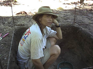
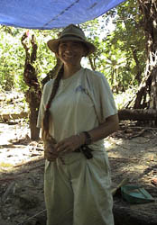
Felicia Beardsley in Unit 4 at Walung
Cleaning up for the day
 We quit the site about lunchtime, which is a good thing because it rained very hard after that, and the winds picked up. Our host Elio had been busy that morning too. He had been fishing with his net and brought in a lot of reef fish and lobster. We had both for lunch. We quit the site about lunchtime, which is a good thing because it rained very hard after that, and the winds picked up. Our host Elio had been busy that morning too. He had been fishing with his net and brought in a lot of reef fish and lobster. We had both for lunch.
The rains had stopped by the time Moses arrived with the boat, but the tide was going out, so we had to slog through the lagoon once again to the edge of the reef. The crew took the first boat; Stan, his family and I waited for the second boat.
July 12, 1999
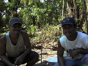
Today started out rainy and continued through the day, accompanied by big winds. There were few periods of simple drizzle which would allow us to work in relative comfort. One of those periods was this morning, on our boat ride out to the site. The seas were rough, both coming and going from Walung, but at least the morning's trek was without rain. This week the tide allows us to go back and forth on a daily basis. Two of the crew have opted to stay in Walung for the week; I am going back and forth with the remainder, along with Nena. No Stan this week.
We finished our mapping today, with the remaining midden concentrations and the stray boulder (hopeful foundation alignment) included in that work. It was good to have Nena at the site, as he had mapped the compound wall. I pointed out some of the areas of possible foundations Stan and I had located over the last couple of weeks, and of course wondered if what we were seeing looked like foundations to him or if they seemed part of the wall debris. Nena has a good sense about these sorts of features and will talk them through, pointing out why he agrees or disagrees with your interpretation. In one instance, he thought two of our possible pavements were actually part of the wall, but noted that we also may have located an opening in that wall by identifying the gap between these "pavements"; something he was unable to do during his session of mapping. I had actually demonstrated this opening or gap by noting an alignment for one of these "pavements" as one course above the ground: one course up, then down and across this opening or gap, and one course up again for the second "pavement," also defined by an alignment of corals. He agreed with our interpretation of the other pavements and foundations.
While we continued mapping, Nena took over the excavations, expanding the excavations by another meter to expose the full extent of the hearth Stan had encountered last week. Nena then excavated the hearth itself, and found small deposits of ash, charcoal, lots and lots of shell and fire-cracked rock, and bone (fish, predominately). This is as far as he got today. Considering the circumstances under which he was working, I think he made great progress.
No pictures for today owing to the rain.
July 13, 1999
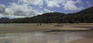
Arriving at low tide
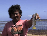 Today was a much better day than yesterday; for one thing, no really grey ominous skies. We arrived at the site during low tide; it will remain low in the mornings this week, which means we get out of the boat at the reef and walk to the shore. The water is generally below our knees, and provides some wonderful views of tidepools along the way. Nena and I were both straggling behind the crew in our walk to shore; I was looking at tidepools and taking pictures (a puffer fish trapped in the low waters and a frilly sea cucumber), while Nena was wandering in his own fashion through the seagrass meadows. He caught a fish too! It was resting in the grasses and trying to hide, but Nena spotted it, reached down and grabbed it, with his bare hands. That became his lunch for the day. Today was a much better day than yesterday; for one thing, no really grey ominous skies. We arrived at the site during low tide; it will remain low in the mornings this week, which means we get out of the boat at the reef and walk to the shore. The water is generally below our knees, and provides some wonderful views of tidepools along the way. Nena and I were both straggling behind the crew in our walk to shore; I was looking at tidepools and taking pictures (a puffer fish trapped in the low waters and a frilly sea cucumber), while Nena was wandering in his own fashion through the seagrass meadows. He caught a fish too! It was resting in the grasses and trying to hide, but Nena spotted it, reached down and grabbed it, with his bare hands. That became his lunch for the day.
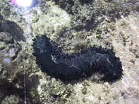
Sea cucumber |
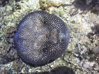
Puffer fish |
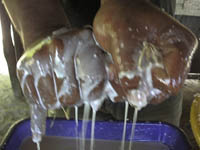
When we got to Elio's compound, Alik (who had opted to stay the week in Walung) was assisting Elio in preparing coconut milk for cooking into oil. The grated coconut is wrapped in hibiscus bark and squeezed into a pan. That milk is in turn cooked over a low fire and the oil skimmed off. It is a very involved process, and made me appreciate the coconut oil all the more.
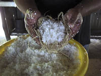
Coconut oil --- 1
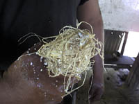
Coconut oil --- 2 |
Coconut oil --- 3 |
At the site, Nena and his crew continued their excavations, going below the hearth he dug out yesterday. We (me and my crew) began a new excavation unit in another part of the site. The question, though, was where to begin. This is a big site, really big, with so many possibilities for the placement of excavations. I decided on placing something near a house foundation that sits in the southeastern part of the site; it is a complete foundation consisting of a coral boulder alignment. I chose to place our Unit 4 (Nena has Units 1, 2 and 3) in a small inset area of the foundation; this area probably served as an entryway.
Walung Unit 4, level 2
As my guys set out the excavation unit, I set up the screen in a location central to both me and Nena; we only have the one screen, and we both will be using it. Alik did all our screening, while Junior and Burdy dug the unit; they would not let me dig. Junior did most of the digging. He was working on his technique, I think, and would get one corner of the unit to level and peel the rest of the level back, making every effort to keep the unit floor even all the way across. I ended up writing the unit notes, until Burdy took over that task as well. I spent my time either doing touch-up work on Junior's levels, or running between the screen and Nena's excavations. The only time I actually got to do any digging was when my crew went on break.
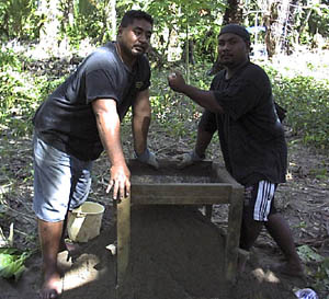
Alik and Yos on the screen
Burdy and Jun
The house-alignment photograph is taken from one corner and down one wall. The wall alignment ends just before our excavation unit and turns toward the right, toward the breadfruit tree.
House alignment
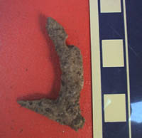
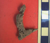
It was during their lunch break that I was able to really stick my trowel in the ground without anyone maneuvering me away. And what a reward! A complete coral fishhook practically leaped from the soil of the unit. It is a one-piece jabbing hook complete with grooves resulting from the attachment of the line to the hook. No one believed me when I showed it to them, until I pointed out each of the modifications on the coral for the hook, the nob at the top of the shaft, the line grooves. Then they got excited and started looking more carefully at the coral and other things coming out of the unit and the screen. It also provided a good demonstration of why we keep everything coming out of the excavations, other than soil and roots. I hadn't expected this. It was an unusual find; moreover, nothing like this has ever been reported from any of the sites on the island, from any of the previous excavations. This is something new to the island's archaeological inventory. A new find, a new industry. Now, I need to get to a library and see if coral fishhooks show up elsewhere in the Pacific.
Coral fishhook from the excavation |
Coral fishhook showing line marks |
Next: Wrapping up the project
|
|
|
